
Narayani topographic map
Interactive map
Click on the map to display elevation.
About this map
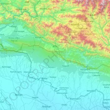
Name: Narayani topographic map, elevation, terrain.
Location: Narayani, Central Development Region, Nepal (26.74474 83.91936 27.88088 85.51062)
Average elevation: 568 m
Minimum elevation: 59 m
Maximum elevation: 3,976 m
Other topographic maps
Click on a map to view its topography, its elevation and its terrain.
Chillime
Nepal > Central Development Region > Chillime
Chillime, Rasuwa, Bagmati, Central Development Region, Nepal
Average elevation: 2,194 m
Lantan
Nepal > Central Development Region > Lantan
Lantan, Rasuwa, Bagmati, Central Development Region, Nepal
Average elevation: 5,161 m
Chilime Khola
Nepal > Central Development Region
Chilime Khola, Rasuwa, Bagmati, Central Development Region, Nepal
Average elevation: 2,388 m
Bagmati
Nepal > Central Development Region
Bagmati, Central Development Region, Nepal
Average elevation: 2,279 m
Amlekhganj
Nepal > Central Development Region > Amlekhganj
Amlekhganj, Bara, Narayani, Central Development Region, Nepal
Average elevation: 397 m