
Himalayas topographic map
Interactive map
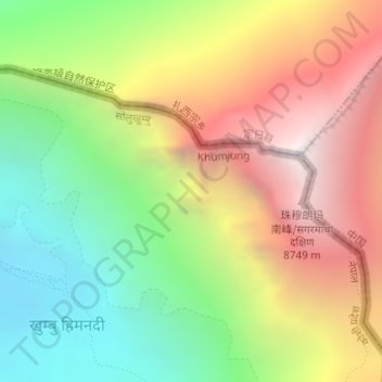
Click on the map to display elevation.
About this map
Name: Himalayas topographic map, elevation, terrain.
Average elevation: 7,555 m
Minimum elevation: 6,448 m
Maximum elevation: 8,849 m
The Himalayas, or Himalaya (/ˌhɪməˈleɪə, hɪˈmɑːləjə/; Sanskrit: IPA: , himá "snow", ā-laya "dwelling", "abode"), are a mountain range in Asia separating the plains of the Indian subcontinent from the Tibetan Plateau. The range has some of the planet's highest peaks, including the highest, Mount Everest. Over 100 peaks exceeding 7,200 m (23,600 ft) in elevation lie in the Himalayas. By contrast, the highest peak outside Asia (Aconcagua, in the Andes) is 6,961 m (22,838 ft) tall.
Other topographic maps
Click on a map to view its topography, its elevation and its terrain.
Tengboche
Nepal > Solukhumbu > Khumjung > Tengboche
Tengboche, Khumjung, Khumbupasanglahmu, Solukhumbu, Province #1, Nepal
Average elevation: 3,936 m
Gokyo Ri
Nepal > Solukhumbu > Khumjung
Gokyo Ri, Khumjung, Khumbupasanglahmu, Solukhumbu, Province #1, Nepal
Average elevation: 4,968 m
Khumbu Glacier
Nepal > Solukhumbu > Khumjung
Khumbu Glacier, Khumjung, Khumbupasanglahmu, Solukhumbu, Province #1, Nepal
Average elevation: 6,296 m