
Vanier Island topographic map
Interactive map
Click on the map to display elevation.
About this map
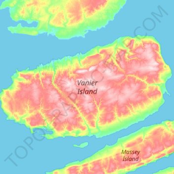
Name: Vanier Island topographic map, elevation, terrain.
Location: Vanier Island, Nunavut, Canada (76.04072 -104.47775 76.32465 -102.50558)
Average elevation: 63 m
Minimum elevation: -5 m
Maximum elevation: 253 m
Other topographic maps
Click on a map to view its topography, its elevation and its terrain.
Cornwallis Island
Cornwallis Island, Qikiqtani Region, Nunavut, X0A 0V0, Canada
Average elevation: 73 m
Prince of Wales Island
Prince of Wales Island, Nunavut, Canada
Average elevation: 31 m
Victoria and Albert Mountains
Victoria and Albert Mountains, Nunavut, Canada
Average elevation: 743 m
Sirmilik National Park
Sirmilik National Park, Nunavut, Canada
Average elevation: 338 m