
Dead Sea topographic map
Interactive map
Click on the map to display elevation.
About this map
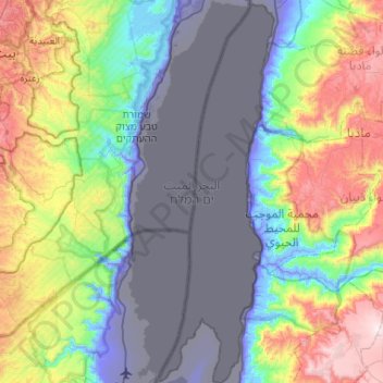
Name: Dead Sea topographic map, elevation, terrain.
Location: Dead Sea, Area C, Judea and Samaria, Palestinian Territory (31.31720 35.39027 31.76477 35.59168)
Average elevation: 105 m
Minimum elevation: -415 m
Maximum elevation: 1,061 m
The lake's surface is 430.5 metres (1,412 ft) below sea level, making its shores the lowest land-based elevation on Earth. It is 304 m (997 ft) deep, the deepest hypersaline lake in the world. With a salinity of 342 g/kg, or 34.2% (in 2011), it is one of the world's saltiest bodies of water – 9.6 times as salty as the ocean – and has a density of 1.24 kg/litre, which makes swimming similar to floating. This salinity makes for a harsh environment in which plants and animals cannot flourish, hence its name. The Dead Sea's main, northern basin is 50 kilometres (31 mi) long and 15 kilometres (9 mi) wide at its widest point.