
Ysyk-Ata River topographic map
Interactive map
Click on the map to display elevation.
About this map
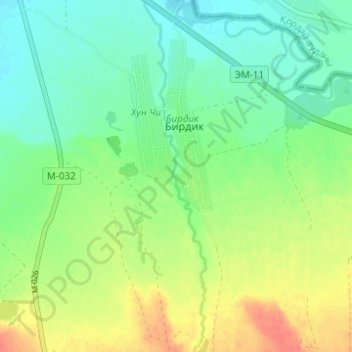
Name: Ysyk-Ata River topographic map, elevation, terrain.
Location: Ysyk-Ata River, Ysyk-Ata District, Chuy Region, Kyrgyzstan (42.92851 74.89635 42.97365 74.90714)
Average elevation: 691 m
Minimum elevation: 672 m
Maximum elevation: 720 m
Other topographic maps
Click on a map to view its topography, its elevation and its terrain.
Кеминский район
Kyrgyzstan > Chuy Region > Кеминский район
Кеминский район, Chuy Region, Kyrgyzstan
Average elevation: 1,980 m
Каратор
Каратор, Sokuluk District, Chuy Region, Kyrgyzstan
Average elevation: 3,779 m