
City of Johannesburg Metropolitan Municipality topographic map
Interactive map
Click on the map to display elevation.
About this map
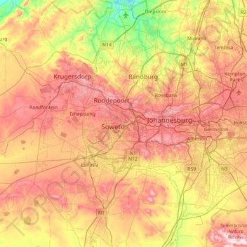
Name: City of Johannesburg Metropolitan Municipality topographic map, elevation, terrain.
Location: City of Johannesburg Metropolitan Municipality, Gauteng, RSA (-26.52629 27.71427 -25.90283 28.21446)
Average elevation: 1,582 m
Minimum elevation: 1,275 m
Maximum elevation: 1,909 m
Other topographic maps
Click on a map to view its topography, its elevation and its terrain.
Mogale City Ward 27
RSA > Gauteng > Mogale City Local Municipality
Mogale City Ward 27, Mogale City Local Municipality, West Rand District Municipality, Gauteng, RSA
Average elevation: 1,602 m
Tshwane Ward 61
Tshwane Ward 61, Pretoria, City of Tshwane Metropolitan Municipality, Gauteng, RSA
Average elevation: 1,427 m