
Alabama topographic map
Interactive map
Click on the map to display elevation.
About this map
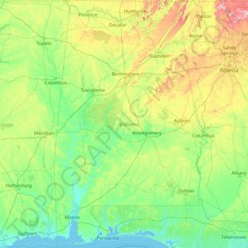
Name: Alabama topographic map, elevation, terrain.
Location: Alabama, United States (30.14338 -88.47310 35.00811 -84.88829)
Average elevation: 136 m
Minimum elevation: -3 m
Maximum elevation: 1,232 m
Alabama is bordered by the states of Tennessee to the north, Georgia to the east, Florida to the south, and Mississippi to the west. Alabama has coastline at the Gulf of Mexico, in the extreme southern edge of the state. The state ranges in elevation from sea level at Mobile Bay to more than 2,000 feet (610 m) in the northeast, to Mount Cheaha at 2,413 ft (735 m).
Other topographic maps
Click on a map to view its topography, its elevation and its terrain.
Brooklyn
United States > New York > New York
Brooklyn, Kings County, New York, United States
Average elevation: 9 m
Houston
United States > Texas > Harris County
Houston, Harris County, Texas, United States
Average elevation: 25 m
Santa Cruz
United States > California > Santa Cruz County
Santa Cruz, Santa Cruz County, California, United States
Average elevation: 89 m
New Orleans
United States > Louisiana > Orleans Parish
New Orleans, Orleans Parish, Louisiana, United States
Average elevation: 1 m
Albuquerque
United States > New Mexico > Bernalillo County
Albuquerque, Bernalillo County, New Mexico, United States
Average elevation: 1,688 m
Sacramento
United States > California > Sacramento County
Sacramento, Sacramento County, California, United States
Average elevation: 10 m
Jacksonville
United States > Florida > Duval County
Jacksonville, Duval County, Florida, United States
Average elevation: 10 m
Queens County
United States > New York > New York
Queens County, New York, United States
Average elevation: 11 m
Spokane
United States > Washington > Spokane County
Spokane, Spokane County, Washington, United States
Average elevation: 655 m
Staten Island
United States > New York > New York
Staten Island, Richmond County, New York, United States
Average elevation: 9 m
Somerville
United States > Massachusetts > Middlesex County
Somerville, Middlesex County, Massachusetts, United States
Average elevation: 11 m
Lexington
United States > Kentucky > Lexington
Lexington, Fayette County, Kentucky, 40508, United States
Average elevation: 285 m
Madison
United States > Wisconsin > Dane County
Madison, Dane County, Wisconsin, United States
Average elevation: 284 m
Santa Fe
United States > New Mexico > Santa Fe County
Santa Fe, Santa Fe County, New Mexico, United States
Average elevation: 2,221 m
Kauai
United States > Hawaii > Kauaʻi County
Kauai, Kauaʻi County, Hawaii, United States
Average elevation: 216 m
Hillsborough County
Hillsborough County, Florida, United States
Average elevation: 20 m
Baltimore
United States > Maryland > Baltimore
Baltimore, Maryland, 21233, United States
Average elevation: 65 m