
Paducah topographic map
Interactive map
Click on the map to display elevation.
About this map
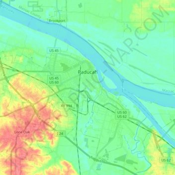
Name: Paducah topographic map, elevation, terrain.
Location: Paducah, McCracken County, Kentucky, United States (37.03683 -88.73290 37.10521 -88.56064)
Average elevation: 108 m
Minimum elevation: 91 m
Maximum elevation: 149 m
Other topographic maps
Click on a map to view its topography, its elevation and its terrain.
West Paducah
United States > Kentucky > McCracken County
West Paducah, McCracken County, Kentucky, 42086, United States
Average elevation: 110 m
Grahamville
United States > Kentucky > McCracken County > Grahamville
Grahamville, McCracken County, Kentucky, 42086, United States
Average elevation: 115 m
Paducah
United States > Kentucky > McCracken County > Paducah
Paducah, McCracken County, Kentucky, 42002, United States
Average elevation: 117 m