
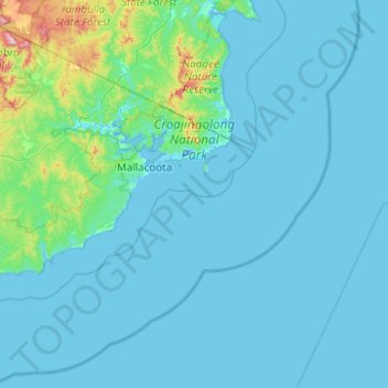
Croajingolong National Park topographic map
Interactive map
Click on the map to display elevation.
About this map
Name: Croajingolong National Park topographic map, elevation, terrain.
Average elevation: 50 m
Minimum elevation: -7 m
Maximum elevation: 802 m
Other topographic maps
Click on a map to view its topography, its elevation and its terrain.
Mount Bogong
Mount Bogong, Shire of East Gippsland, Victoria, Australia
Average elevation: 1,719 m
Melbourne Water Pipe Reserve
Australia > Victoria > Melbourne
Melbourne Water Pipe Reserve, Burwood East, Melbourne, City of Whitehorse, Victoria, Australia
Average elevation: 118 m
Shire of Mansfield
Shire of Mansfield, Victoria, Australia
Average elevation: 748 m
Langwarrin
Langwarrin, City of Frankston, Victoria, 3910, Australia
Average elevation: 71 m
Mount Fraser
Mount Fraser, Shire of Mitchell, Hume, Victoria, 3753, Australia
Average elevation: 309 m
Mount Strickland
Mount Strickland, Shire of Murrindindi, Hume, Victoria, Australia
Average elevation: 868 m
Lara District
Australia > Victoria > Geelong
Lara District, Shearers Lane, Lara, Geelong, City of Greater Geelong, Barwon South West, Victoria, 3212, Australia
Average elevation: 94 m
Mount Feathertop
Mount Feathertop, Alpine Shire, Hume, Victoria, Australia
Average elevation: 1,533 m
Mount Dawson
Mount Dawson, Shire of East Gippsland, Gippsland, Victoria, Australia
Average elevation: 435 m
Badger Creek
Australia > Victoria > Healesville
Badger Creek, Healesville, Shire of Yarra Ranges, Victoria, Australia
Average elevation: 255 m
Basalt Lake
Australia > Victoria > Harkaway
Basalt Lake, Board Walk, Berwick, Harkaway, City of Casey, Victoria, 3806, Australia
Average elevation: 76 m
Wilsons Promontory National Park
Wilsons Promontory National Park, Vereker Outlook, Wilsons Promontory, Shire of South Gippsland, Gippsland, Victoria, Australia
Average elevation: 32 m