
ᕿᑭᖅᑖᓗᒃ Baffin Island topographic map
Interactive map
Click on the map to display elevation.
About this map
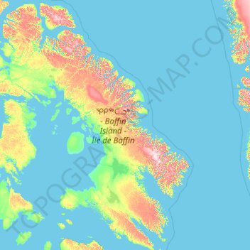
Name: ᕿᑭᖅᑖᓗᒃ Baffin Island topographic map, elevation, terrain.
Location: ᕿᑭᖅᑖᓗᒃ Baffin Island, X0A 0H0, Canada (61.86201 -90.11200 73.86118 -61.26000)
Average elevation: 132 m
Minimum elevation: -2 m
Maximum elevation: 2,002 m
The Baffin Mountains run along the northeastern coast of the island and are a part of the Arctic Cordillera. The highest peak is Mount Odin, with an elevation of at least 2,143 m (7,031 ft), although some sources say 2,147 m (7,044 ft). Another peak of note is Mount Asgard, located in Auyuittuq National Park, with an elevation of 2,011 m (6,598 ft). Mount Thor, with an elevation of 1,675 m (5,495 ft), is said to have the greatest purely vertical drop (a sheer cliff face) of any mountain on Earth, at 1,250 m (4,100 ft). Mount Sharat, with an elevation of 422 m (1,385 ft) and a prominence of 67 m (220 ft) is located on Baffin Island. The mountain is named after geologist Sarat Kumar Rai, the chief geology curator in the Field Museum of Natural History, Chicago. Rai or Roy, a native of India, studied in India, London, and earned his Ph.D. at the University of Chicago. Shortly after he started at the Field Museum he joined the 1927-1928 Rawson-Macmillan Expedition to Baffin Island and Labrador. This 15-month expedition began in June 1927.
Other topographic maps
Click on a map to view its topography, its elevation and its terrain.
Cornwallis Island
Cornwallis Island, Qikiqtani Region, Nunavut, X0A 0V0, Canada
Average elevation: 73 m
Prince of Wales Island
Prince of Wales Island, Nunavut, Canada
Average elevation: 31 m
Victoria and Albert Mountains
Victoria and Albert Mountains, Nunavut, Canada
Average elevation: 743 m
Sirmilik National Park
Sirmilik National Park, Nunavut, Canada
Average elevation: 338 m