
El Espino topographic map
Interactive map
Click on the map to display elevation.
About this map
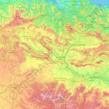
Name: El Espino topographic map, elevation, terrain.
Location: El Espino, Castile and León, 09219, Spain (42.08743 -3.68777 43.36743 -2.40777)
Average elevation: 732 m
Minimum elevation: -1 m
Maximum elevation: 2,163 m
Other topographic maps
Click on a map to view its topography, its elevation and its terrain.
Arévalo
Arévalo, Ávila, Castile and León, 05200, Spain
Average elevation: 845 m
La Maya
Spain > Castile and León > La Maya
La Maya, Tierra de Alba, Salamanca, Castile and León, Spain
Average elevation: 850 m
Burgos
Spain > Castile and León > Burgos
Burgos, Alfoz de Burgos, Burgos, Castile and León, Spain
Average elevation: 907 m
Atua
Spain > Castile and León > Condado de Treviño
Atua, Condado de Treviño, Ebro, Burgos, Castile and León, Spain
Average elevation: 629 m
Contreras
Spain > Castile and León > Contreras
Contreras, Sierra de la Demanda, Burgos, Castile and León, Spain
Average elevation: 1,089 m
Pico Almanzor
Spain > Castile and León > Candeleda
Pico Almanzor, Candeleda, Comarca de Arenas de San Pedro, Ávila, Castile and León, Spain
Average elevation: 2,159 m