
Polson topographic map
Interactive map
Click on the map to display elevation.
About this map
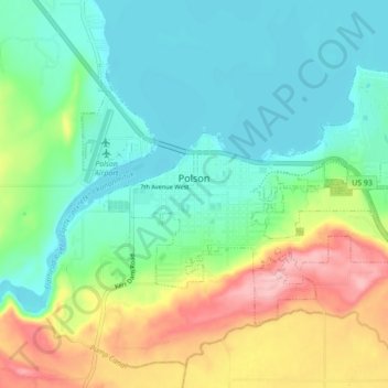
Name: Polson topographic map, elevation, terrain.
Location: Polson, Lake County, Montana, United States (47.66865 -114.18891 47.70765 -114.10253)
Average elevation: 929 m
Minimum elevation: 877 m
Maximum elevation: 1,044 m
Other topographic maps
Click on a map to view its topography, its elevation and its terrain.
Saint Ignatius
United States > Montana > Lake County
Saint Ignatius, Lake County, Montana, 59865, United States
Average elevation: 893 m
Flathead Lake
United States > Montana > Lake County
Flathead Lake, Lake County, Montana, United States
Average elevation: 1,168 m
North Swan Valley Wildlife Management Area
United States > Montana > Lake County
North Swan Valley Wildlife Management Area, Lake County, Montana, United States
Average elevation: 1,231 m
Moore Lake
United States > Montana > Lake County
Moore Lake, Lake County, Montana, United States
Average elevation: 1,806 m
Estes Lake
United States > Montana > Lake County
Estes Lake, Lake County, Montana, United States
Average elevation: 1,068 m
Kicking Horse
United States > Montana > Lake County
Kicking Horse, Lake County, Montana, United States
Average elevation: 938 m
Big Arm
United States > Montana > Lake County
Big Arm, Lake County, Montana, 59910, United States
Average elevation: 1,064 m
Mission Valley Historical Marker
United States > Montana > Lake County
Mission Valley Historical Marker, Lake County, Montana, 59865, United States
Average elevation: 909 m