
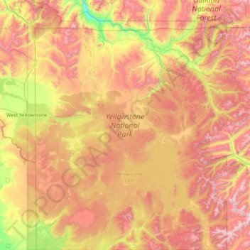
Yellowstone National Park topographic map
Interactive map
Click on the map to display elevation.
About this map
Name: Yellowstone National Park topographic map, elevation, terrain.
Average elevation: 2,450 m
Minimum elevation: 1,560 m
Maximum elevation: 3,549 m
Yellowstone National Park spans an area of 3,468.4 sq mi (8,983 km2), comprising lakes, canyons, rivers, and mountain ranges. Yellowstone Lake is one of the largest high-elevation lakes in North America and is centered over the Yellowstone Caldera, the largest supervolcano on the continent. The caldera is considered a dormant volcano. It has erupted with tremendous force several times in the last two million years. Well over half of the world's geysers and hydrothermal features are in Yellowstone, fueled by this ongoing volcanism. Lava flows and rocks from volcanic eruptions cover most of the land area of Yellowstone. The park is the centerpiece of the Greater Yellowstone Ecosystem, the largest remaining nearly-intact ecosystem in the Earth's northern temperate zone. In 1978, Yellowstone was named a UNESCO World Heritage Site.
Other topographic maps
Click on a map to view its topography, its elevation and its terrain.
Canyon Village
United States > Wyoming > Park County
Canyon Village, Park County, Wyoming, 82190, United States
Average elevation: 2,418 m
Dome Mountain
United States > Wyoming > Park County
Dome Mountain, Park County, Wyoming, United States
Average elevation: 2,647 m
Mount Everts
United States > Wyoming > Park County
Mount Everts, Park County, Wyoming, United States
Average elevation: 2,192 m
Clark
United States > Wyoming > Park County
Clark, Park County, Wyoming, United States
Average elevation: 1,289 m
Obsidian Cliff
United States > Wyoming > Park County
Obsidian Cliff, Park County, Wyoming, United States
Average elevation: 2,361 m
Mount Washburn
United States > Wyoming > Park County
Mount Washburn, Park County, Wyoming, United States
Average elevation: 2,798 m
Sunlight Bridge Overlook
United States > Wyoming > Park County
Sunlight Bridge Overlook, Chief Joseph Highway, Park County, Wyoming, United States
Average elevation: 1,921 m
Cody
United States > Wyoming > Park County
Cody, Park County, Wyoming, United States
Average elevation: 1,557 m
Hayden Valley
United States > Wyoming > Park County
Hayden Valley, Park County, Wyoming, United States
Average elevation: 2,373 m
Inspiration Point
United States > Wyoming > Park County
Inspiration Point, North Rim Trail, Park County, Wyoming, 82190, United States
Average elevation: 2,367 m
Powell
United States > Wyoming > Park County > Powell
Powell, Park County, Wyoming, United States
Average elevation: 1,391 m
Meeteetse
United States > Wyoming > Park County
Meeteetse, Park County, Wyoming, United States
Average elevation: 1,791 m
Wapiti
United States > Wyoming > Park County
Wapiti, Park County, Wyoming, 82450, United States
Average elevation: 1,794 m