
Albany topographic map
Click on the map to display elevation.
About this map
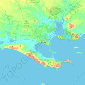
Name: Albany topographic map, elevation, terrain.
Location: Albany, City of Albany, Western Australia, 6330, Australia (-35.18478 117.72361 -34.86478 118.04361)
Average elevation: 30 m
Minimum elevation: -3 m
Maximum elevation: 226 m
Other topographic maps
Click on a map to view its topography, its elevation and its terrain.
Mount Barker
The peak of Mount Barker lies 3.5 kilometres (2.2 mi) southwest of the town centre, and reaches an elevation of 404 metres (1,325 ft) above sea level. A sealed road leads to the base of a radio and television tower on the summit of the hill. The tower was constructed to a height of 168 metres (551 ft) in 1966,…
Average elevation: 211 m
Purnululu National Park
The Bungle Bungle Range, lying fully within the park, has elevations as high as 578 metres (1,896 ft) above sea level. It is famous for the sandstone domes, unusual and visually striking with their striping in alternating orange and grey bands. The banding of the domes is due to differences in clay content and…
Average elevation: 277 m