
Elgin topographic map
Interactive map
Click on the map to display elevation.
About this map
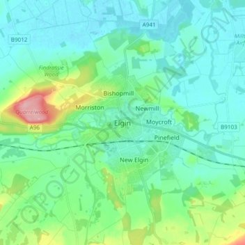
Name: Elgin topographic map, elevation, terrain.
Location: Elgin, Moray, Scotland, IV30 1EA, United Kingdom (57.60879 -3.35485 57.68879 -3.27485)
Average elevation: 26 m
Minimum elevation: -1 m
Maximum elevation: 125 m
Elgin is first documented in the Cartulary of Moray in 1190 AD. It was created a royal burgh in the 12th century by King David I of Scotland, and by that time had a castle on top of the present-day Lady Hill to the west of the town. The origin of the name Elgin is likely to be Celtic. It may derive from 'Aille' literally signifying beauty, but in topography a beautiful place or valley. Another possibility is 'ealg', meaning both 'Ireland' and 'worthy'. The termination 'gin' or 'in' are Celtic endings signifying little or diminutive forms, hence Elgin could mean beautiful place, worthy place or little Ireland.
Other topographic maps
Click on a map to view its topography, its elevation and its terrain.
Cullen
United Kingdom > Scotland > Moray
Cullen, Moray, Scotland, AB56 4SN, United Kingdom
Average elevation: 45 m
Dallas
United Kingdom > Scotland > Moray
Dallas, Moray, Scotland, IV36 2SA, United Kingdom
Average elevation: 205 m
Urquhart
United Kingdom > Scotland > Moray
Urquhart, Moray, Scotland, IV30 8GL, United Kingdom
Average elevation: 32 m
Auchindoun Castle
United Kingdom > Scotland > Moray > Dufftown
Auchindoun Castle, A941, Dufftown, Moray, Scotland, AB55 4DR, United Kingdom
Average elevation: 274 m
Arradoul
United Kingdom > Scotland > Moray
Arradoul, Moray, Scotland, AB56 5BB, United Kingdom
Average elevation: 52 m
Mosstodloch
United Kingdom > Scotland > Moray
Mosstodloch, Moray, Scotland, IV32 7JD, United Kingdom
Average elevation: 37 m
Ben Rinnes
United Kingdom > Scotland > Moray
Ben Rinnes, Moray, Scotland, AB55 4DB, United Kingdom
Average elevation: 539 m
Thomshill
United Kingdom > Scotland > Moray
Thomshill, Moray, Scotland, IV30 8GY, United Kingdom
Average elevation: 73 m
Upper Knockando
United Kingdom > Scotland > Moray
Upper Knockando, Moray, Scotland, AB38 7RX, United Kingdom
Average elevation: 201 m
Auchenhalrig
United Kingdom > Scotland > Moray > Upper Dallachy
Auchenhalrig, Upper Dallachy, Moray, Scotland, IV32 7PP, United Kingdom
Average elevation: 40 m
Aberlour
United Kingdom > Scotland > Moray
Aberlour, Moray, Scotland, AB38 9PX, United Kingdom
Average elevation: 160 m
Broom of Moy
United Kingdom > Scotland > Moray
Broom of Moy, Moray, Scotland, IV36 2SR, United Kingdom
Average elevation: 14 m
Forres
United Kingdom > Scotland > Moray
Forres, Moray, Scotland, IV36 1NX, United Kingdom
Average elevation: 31 m
Findhorn Bay
United Kingdom > Scotland > Moray > Findhorn
Findhorn Bay, Findhorn, Moray, Scotland, United Kingdom
Average elevation: 3 m
Marypark
United Kingdom > Scotland > Moray
Marypark, Moray, Scotland, AB37 9BH, United Kingdom
Average elevation: 219 m
Fochabers
United Kingdom > Scotland > Moray
Fochabers, Moray, Scotland, United Kingdom
Average elevation: 59 m
Keith
United Kingdom > Scotland > Moray
Keith, Moray, Scotland, AB55 5FF, United Kingdom
Average elevation: 180 m
Glenlivet
United Kingdom > Scotland > Moray
Glenlivet, Moray, Scotland, AB37 9BT, United Kingdom
Average elevation: 280 m
Lossiemouth
United Kingdom > Scotland > Moray
Lossiemouth, Moray, Scotland, IV31 6NU, United Kingdom
Average elevation: 3 m
Findhorn
United Kingdom > Scotland > Moray
Findhorn, Moray, Scotland, IV36 3YG, United Kingdom
Average elevation: 3 m
Dufftown
United Kingdom > Scotland > Moray
Dufftown, Moray, Scotland, AB55 4AD, United Kingdom
Average elevation: 268 m
Duffus
United Kingdom > Scotland > Moray > Duffus
Duffus, Moray, Scotland, IV30 5QL, United Kingdom
Average elevation: 21 m
Ballindalloch
United Kingdom > Scotland > Moray > Ballindalloch
Ballindalloch, Moray, Scotland, AB37 9YF, United Kingdom
Average elevation: 233 m
Rothes
United Kingdom > Scotland > Moray
Rothes, Moray, Scotland, AB38 7AZ, United Kingdom
Average elevation: 139 m
Brodie
United Kingdom > Scotland > Moray
Brodie, Moray, Scotland, IV36 2TD, United Kingdom
Average elevation: 34 m
Craigellachie
United Kingdom > Scotland > Moray
Craigellachie, Moray, Scotland, AB38 9SZ, United Kingdom
Average elevation: 154 m
Tomintoul
United Kingdom > Scotland > Moray
Tomintoul, Moray, Scotland, AB37 9ET, United Kingdom
Average elevation: 374 m
Portknockie
United Kingdom > Scotland > Moray > Portknockie
Portknockie, Moray, Scotland, AB56 4LR, United Kingdom
Average elevation: 22 m
Rathven
United Kingdom > Scotland > Moray
Rathven, Moray, Scotland, AB56 4DG, United Kingdom
Average elevation: 42 m
Buckie
United Kingdom > Scotland > Moray
Buckie, Moray, Scotland, AB56 1AH, United Kingdom
Average elevation: 43 m
Burghead
United Kingdom > Scotland > Moray
Burghead, Moray, Scotland, IV30 5XJ, United Kingdom
Average elevation: 6 m
Kinloss
United Kingdom > Scotland > Moray > Kinloss
Kinloss, Moray, Scotland, IV36 3UT, United Kingdom
Average elevation: 10 m
Mulben
United Kingdom > Scotland > Moray
Mulben, Moray, Scotland, AB55 6XJ, United Kingdom
Average elevation: 172 m
Spey Bay
United Kingdom > Scotland > Moray
Spey Bay, Moray, Scotland, IV32 7RR, United Kingdom
Average elevation: 5 m
Arradoul
United Kingdom > Scotland > Moray > Buckie
Arradoul, Buckie, Moray, Scotland, AB56 5AP, United Kingdom
Average elevation: 71 m
Milltown of Rothiemay
United Kingdom > Scotland > Moray
Milltown of Rothiemay, Moray, Scotland, AB54 7LE, United Kingdom
Average elevation: 137 m
Hopeman
United Kingdom > Scotland > Moray
Hopeman, Moray, Scotland, IV30 5TF, United Kingdom
Average elevation: 20 m