
Lilydale topographic map
Interactive map
Click on the map to display elevation.
About this map
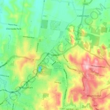
Name: Lilydale topographic map, elevation, terrain.
Location: Lilydale, Shire of Yarra Ranges, Victoria, 3140, Australia (-37.79766 145.31241 -37.71766 145.39241)
Average elevation: 133 m
Minimum elevation: 50 m
Maximum elevation: 267 m
Other topographic maps
Click on a map to view its topography, its elevation and its terrain.
Lillydale Lake
Australia > Victoria > Lilydale
Lillydale Lake, Olinda Creek Trail, Lilydale, Shire of Yarra Ranges, Victoria, 3140, Australia
Average elevation: 133 m