
district de Kourchim topographic map
Interactive map
Click on the map to display elevation.
About this map
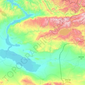
Name: district de Kourchim topographic map, elevation, terrain.
Location: district de Kourchim, Kazakhstan-Oriental, Kazakhstan (47.79827 83.42331 49.11727 86.81922)
Average elevation: 923 m
Minimum elevation: 387 m
Maximum elevation: 3,272 m
Other topographic maps
Click on a map to view its topography, its elevation and its terrain.
Öskemen
Kazakhstan > Kazakhstan-Oriental > Öskemen
Öskemen, Усть-Каменогорск Г.А., Kazakhstan-Oriental, 070003, Kazakhstan
Average elevation: 385 m
Маркаколь
Kazakhstan > Kazakhstan-Oriental > Маркаколь
Маркаколь, Курчумский район, Kazakhstan-Oriental, Kazakhstan
Average elevation: 618 m