
Homestead topographic map
Interactive map
Click on the map to display elevation.
About this map
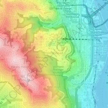
Name: Homestead topographic map, elevation, terrain.
Location: Homestead, Portland, Multnomah County, Oregon, USA (45.48552 -122.69838 45.50594 -122.67686)
Average elevation: 137 m
Minimum elevation: 2 m
Maximum elevation: 319 m
Other topographic maps
Click on a map to view its topography, its elevation and its terrain.
Mount Tabor
Mount Tabor, Portland, Multnomah County, Oregon, 97215, USA
Average elevation: 86 m