
Gooik topographic map
Interactive map
Click on the map to display elevation.
About this map
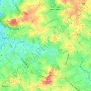
Name: Gooik topographic map, elevation, terrain.
Location: Gooik, Halle-Vilvoorde, Vlaams-Brabant, Vlaanderen, België (50.77953 4.05310 50.81643 4.14530)
Average elevation: 55 m
Minimum elevation: 16 m
Maximum elevation: 111 m
Other topographic maps
Click on a map to view its topography, its elevation and its terrain.
Woestijn
België > Vlaams-Brabant > Halle-Vilvoorde > Gooik > Woestijn
Woestijn, Gooik, Halle-Vilvoorde, Vlaams-Brabant, Vlaanderen, 9403, België
Average elevation: 47 m