
Corroios topographic map
Interactive map
Click on the map to display elevation.
About this map
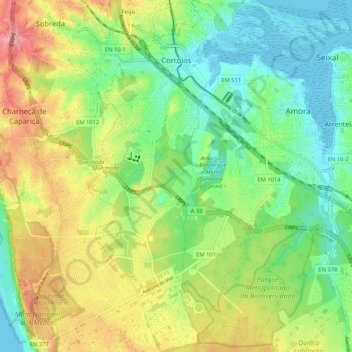
Name: Corroios topographic map, elevation, terrain.
Location: Corroios, Seixal, Setúbal, Portugal (38.57374 -9.17835 38.65543 -9.12311)
Average elevation: 42 m
Minimum elevation: -3 m
Maximum elevation: 106 m
Other topographic maps
Click on a map to view its topography, its elevation and its terrain.
Fernão Ferro
Fernão Ferro, Seixal, Setúbal, Portugal
Average elevation: 49 m
Casal do Marco
Casal do Marco, Seixal, Arrentela e Aldeia de Paio Pires, Seixal, Setúbal, 2840-183, Portugal
Average elevation: 24 m
Fernão Ferro
Portugal > Setúbal > Seixal > Fernão Ferro
Fernão Ferro, Seixal, Setúbal, 2865-601, Portugal
Average elevation: 61 m