
Gaborone topographic map
Interactive map
Click on the map to display elevation.
Gaborone
Gaborone is situated at 24°39′29″S 25°54′44″E / 24.65806°S 25.91222°E / -24.65806; 25.91222 between Kgale and Oodi Hills, on the Notwane River in the south-eastern corner of Botswana, and 15 kilometres (9.3 mi) from the South African border The city lies at an elevation of 1,010 metres (3,310 ft) above sea level. Gaborone is surrounded by the following cities: Ramotswa to the southeast, Mogoditshane to the northwest, and Mochudi to the east, and Tlokweng across the river. Most of them are commuter towns for Gaborone. Suburbs in Gaborone include Broadhurst, Gaborone West, The Village, Naledi. Phakalane, an affluent suburb, lies about 13 km north of the city center.
About this map
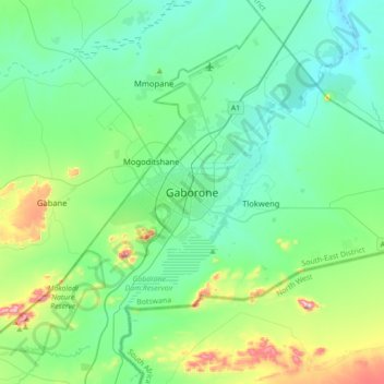
Name: Gaborone topographic map, elevation, terrain.
Location: Gaborone, South-East District, Botswana (-24.81814 25.74885 -24.49814 26.06885)
Average elevation: 1,032 m
Minimum elevation: 946 m
Maximum elevation: 1,364 m