
Chaves topographic map
Interactive map
Click on the map to display elevation.
About this map
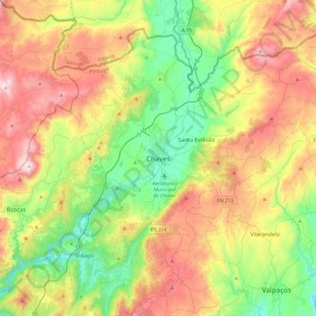
Name: Chaves topographic map, elevation, terrain.
Location: Chaves, Vila Real, Alto Tâmega, Norte, 5400-362, Portugal (41.69995 -7.51148 41.77995 -7.43148)
Average elevation: 416 m
Minimum elevation: 335 m
Maximum elevation: 917 m
Other topographic maps
Click on a map to view its topography, its elevation and its terrain.
Águas Frias
Portugal > Norte > Águas Frias > Chaves > Águas Frias
Águas Frias, Chaves, Vila Real, Alto Tâmega, Norte, Portugal
Average elevation: 720 m