
Alibag topographic map
Interactive map
Click on the map to display elevation.
About this map
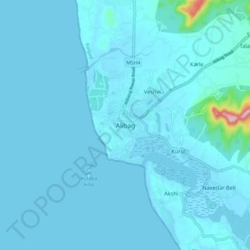
Name: Alibag topographic map, elevation, terrain.
Location: Alibag, Raigad, Maharashtra, 402200, India (18.60984 72.83655 18.68984 72.91655)
Average elevation: 12 m
Minimum elevation: -2 m
Maximum elevation: 255 m
Alibag is located about 120 km south of Mumbai, at 18°38′29″N 72°52′20″E / 18.64139°N 72.87222°E / 18.64139; 72.87222. The average elevation is 0 metres (0 feet).The District Government offices are located along the sea coast road. Alibag is the center place of Raigad District.
Other topographic maps
Click on a map to view its topography, its elevation and its terrain.
Kulaba Fort
India > Maharashtra > Alibag > Alibag
Kulaba Fort, Mahavir Chowk, Alibag, Mumbai Metropolitan Region, Alibag, Raigad, Maharashtra, 402200, India
Average elevation: 1 m
Khanderi Fort
India > Maharashtra > Alibag > Thal
Khanderi Fort, Navgaon Beach ROad, Thal, Mumbai Metropolitan Region, Alibag, Raigad, Maharashtra, India
Average elevation: 0 m
Revdanda Fort
India > Maharashtra > Alibag > Chaul
Revdanda Fort, MSH4, Chaul, Alibag, Raigad, Maharashtra, 402203, India
Average elevation: 5 m
Akshi
India > Maharashtra > Alibag > Akshi
Akshi, Alibag, Raigad, Maharashtra, 402204, India
Average elevation: 5 m
Revadanda
India > Maharashtra > Alibag > Revadanda
Revadanda, Alibag, Raigad, Maharashtra, 402202, India
Average elevation: 7 m