
Boston topographic map
Interactive map
Click on the map to display elevation.
About this map
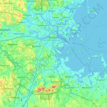
Name: Boston topographic map, elevation, terrain.
Location: Boston, Suffolk County, Massachusetts, United States (42.22791 -71.19124 42.39698 -70.80449)
Average elevation: 25 m
Minimum elevation: -5 m
Maximum elevation: 184 m
Boston has an area of 89.63 square miles (232.1 km2)—48.4 square miles (125.4 km2) (54%) of land and 41.2 square miles (106.7 km2) (46%) of water. The city's official elevation, as measured at Logan International Airport, is 19 ft (5.8 m) above sea level. The highest point in Boston is Bellevue Hill at 330 feet (100 m) above sea level, and the lowest point is at sea level. Situated onshore of the Atlantic Ocean, Boston is the only state capital in the contiguous United States with an oceanic shoreline.