
徐州市 topographic map
Interactive map
Click on the map to display elevation.
About this map
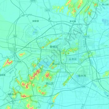
Name: 徐州市 topographic map, elevation, terrain.
Location: 徐州市, 鼓楼区, 徐州市, 江苏省, 221005, 中国 (34.10655 117.02097 34.42655 117.34097)
Average elevation: 43 m
Minimum elevation: 25 m
Maximum elevation: 239 m
徐州地处黄淮平原中部,属北方与南方的过渡地带,四周环山,平原、丘陵相间,属江苏省内平均海拔较高的市。徐州有大洞山、泉山、皇姑山、拉犁山、云龙山、小泰山、卧牛山等山峰,其中主城区有72座山头。位于贾汪区北部的大洞山为全市海拔最高点。
Other topographic maps
Click on a map to view its topography, its elevation and its terrain.