
Make a donation
Martha's Vineyard topographic map
Click on the map to display elevation.
Make a donation
Martha's Vineyard
Martha's Vineyard features a diverse topography characterized by gently rolling hills, sandy beaches, and rugged coastline. The island spans approximately 100 square miles and boasts elevations that reach up to 289 feet at its highest point, offering panoramic views of the surrounding Atlantic Ocean. The terrain is dotted with woodlands, meadows, and wetlands, creating a variety of ecosystems that support a rich array of wildlife. Coastal bluffs and cliffs, particularly along the southern shore, provide dramatic scenery and are shaped by both natural erosion and the forces of the ocean. The island's numerous ponds and inlets add to its scenic beauty, making it a unique blend of maritime and terrestrial landscapes.
Make a donation
About this map
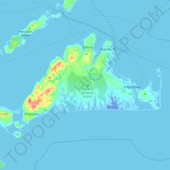
Name: Martha's Vineyard topographic map, elevation, terrain.
Average elevation: 3 m
Minimum elevation: -21 m
Maximum elevation: 85 m
Make a donation
Other topographic maps
Click on a map to view its topography, its elevation and its terrain.