
Purulia - II topographic map
Interactive map
Click on the map to display elevation.
About this map
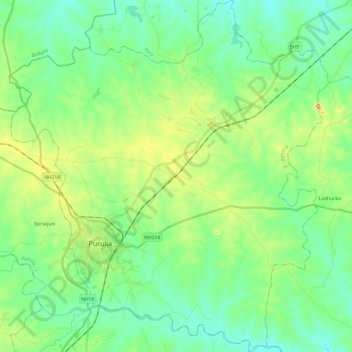
Name: Purulia - II topographic map, elevation, terrain.
Location: Purulia - II, Puruliya, West Bengal, India (23.26134 86.30520 23.48135 86.52287)
Average elevation: 230 m
Minimum elevation: 184 m
Maximum elevation: 354 m
Other topographic maps
Click on a map to view its topography, its elevation and its terrain.
Tarapith
India > West Bengal > Rampurhat - II
Tarapith, Rampurhat - II, Birbhum District, West Bengal, 731233, India
Average elevation: 32 m
Kalimpong
India > West Bengal > Kalimpong
Kalimpong, Kalimpong -I, Kalimpong, West Bengal, 734301, India
Average elevation: 838 m
Darjeeling
India > West Bengal > Darjeeling
Darjeeling, Darjeeling Pulbazar, Darjeeling, West Bengal, 734101, India
Average elevation: 1,331 m
Alipurduar
India > West Bengal > Alipurduar
Alipurduar, Alipurduar - I, Alipurduar, West Bengal, 736121, India
Average elevation: 47 m
Chittaranjan
India > West Bengal > Chittaranjan
Chittaranjan, Salanpur, Paschim Bardhaman, West Bengal, 713331, India
Average elevation: 156 m
Bardhaman
India > West Bengal > Bardhaman
Bardhaman, Barddhamān, Purba Bardhaman, West Bengal, 713101, India
Average elevation: 30 m