
Moortebeek topographic map
Interactive map
Click on the map to display elevation.
About this map
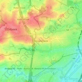
Name: Moortebeek topographic map, elevation, terrain.
Average elevation: 48 m
Minimum elevation: 15 m
Maximum elevation: 86 m
Other topographic maps
Click on a map to view its topography, its elevation and its terrain.
Aa
België > Brussel-Hoofdstad > Anderlecht
Aa, Anderlecht, Brussel-Hoofdstad, Brussel Hoofdstad, 1070, België
Average elevation: 35 m
Anderlecht
België > Brussel-Hoofdstad > Anderlecht
Anderlecht, Brussel-Hoofdstad, Brussel Hoofdstad, 1070, België
Average elevation: 50 m