
Tianjin topographic map
Interactive map
Click on the map to display elevation.
About this map
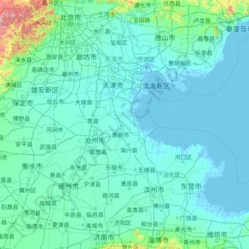
Name: Tianjin topographic map, elevation, terrain.
Location: Tianjin, China (36.56626 113.72998 40.25201 118.05867)
Average elevation: 64 m
Minimum elevation: -4 m
Maximum elevation: 2,561 m
There is 153 km (95 mi) of coastline and 1,137.48 kilometers (706.80 mi) of land border. It lies at the northern end of the Grand Canal of China, which connects with the Yellow River and Yangtze River. The municipality is generally flat, and swampy near the coast, but hilly in the far north, where the Yan Mountains intrude into northern Tianjin. Extensive tidal flats occur on the coastal plain adjacent to the city. The highest point in the municipality is Jiuding Peak (九顶山) in Ji County on the northern border with Hebei, at an altitude of 1,078.5 m (3,538 ft).
Other topographic maps
Click on a map to view its topography, its elevation and its terrain.
桥下村
China > Jiangxi > Jing'an County > Luowan
桥下村, Luowan, Jing'an County, Yichun, Jiangxi, China
Average elevation: 492 m
Guanzhuang
China > Hunan > Yuanling County
Guanzhuang, Yuanling County, Huaihua, Hunan, China
Average elevation: 385 m
Chengguan District
Chengguan District, Lhasa, Tibet, 850000, China
Average elevation: 4,325 m
Longde
China > Ningxia > Longde County
Longde, Longde County, Guyuan City, Ningxia, China
Average elevation: 2,158 m
Guangzhou City
Guangzhou City, Guangdong Province, China
Average elevation: 98 m
Kidney Hill
China > Hong Kong > North District
Kidney Hill, North District, New Territories, Hong Kong, 518032, China
Average elevation: 27 m
Anping County
Anping County, Hengshui, Hebei, 053600, China
Average elevation: 28 m
Yancheng City
China > Jiangsu > Yancheng City
Yancheng City, Jiangsu, 224043, China
Average elevation: 3 m
Dongguan
China > Guangdong Province > Dongguan
Dongguan, Guangdong Province, 523058, China
Average elevation: 20 m
Changzhou
China > Jiangsu > Xinbei District > Changzhou
Changzhou, Xinbei District, Changzhou, Jiangsu, 213000, China
Average elevation: 6 m
Huainan City
China > Anhui > Tianjia'an District > Huainan City
Huainan City, Tianjia'an District, Anhui, China
Average elevation: 40 m
Yantai City
China > Shandong > Yantai City
Yantai City, Shandong, 264000, China
Average elevation: 39 m
Shaxi
China > Guangdong Province > Zhongshan > Shaxi > Shenmingtingcun
Shaxi, Zhongshan, Shenmingtingcun, Guangdong Province, China
Average elevation: 8 m
Hangcheng Sub-district
China > Guangdong Province > Bao'an District > Hangcheng Sub-district
Hangcheng Sub-district, Bao'an District, Shenzhen, Guangdong Province, 518100, China
Average elevation: 21 m
Xinghua City
China > Jiangsu > Xinghua City
Xinghua City, Taizhou, Jiangsu, 225700, China
Average elevation: 3 m
Fuzhou
China > Jiangxi > Fuzhou > Zhongling Subdistrict
Fuzhou, Zhongling Subdistrict, 金巢开发区, Linchuan District, Fuzhou City, Jiangxi, China
Average elevation: 54 m
Kashgar City
China > Xinjiang > Kashgar City
Kashgar, Kashgar City, Kashgar Prefecture, Xinjiang, 844000, China
Average elevation: 1,355 m
North District
North District, New Territories, Hong Kong, China
Average elevation: 115 m
Dongcheng District
China > Beijing > Dongcheng District
Beijing, Dongcheng District, Beijing, 100010, China
Average elevation: 497 m