
Region of Magallanes and Chilean Antarctica topographic map
Interactive map
Click on the map to display elevation.
Region of Magallanes and Chilean Antarctica
The topography can be divided in four regions: an outer archipelago region (Spanish: Región Archipielágica) to the west and south, a mountain region in the west and south (Spanish: Región Cordillerana), a plains region (Spanish: Región de las Planicies Orientales) in the northeast plus a sub-Andean zone in-between the last two zones (Spanish: Región Sub-Andina Oriental).
About this map
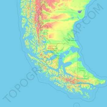
Name: Region of Magallanes and Chilean Antarctica topographic map, elevation, terrain.
Location: Region of Magallanes and Chilean Antarctica, Chile (-56.53830 -75.72252 -48.58223 -66.41599)
Average elevation: 126 m
Minimum elevation: -25 m
Maximum elevation: 3,310 m
Other topographic maps
Click on a map to view its topography, its elevation and its terrain.
Villa Cerro Castillo
Chile > Aysén Region > Provincia de General Carrera > Río Ibáñez
Average elevation: 379 m