
Jhansi topographic map
Interactive map
Click on the map to display elevation.
About this map
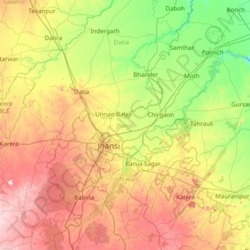
Name: Jhansi topographic map, elevation, terrain.
Location: Jhansi, Uttar Pradesh, India (25.10647 78.30086 25.95527 79.41613)
Average elevation: 232 m
Minimum elevation: 129 m
Maximum elevation: 414 m
Other topographic maps
Click on a map to view its topography, its elevation and its terrain.
Ram Nagar
India > Uttar Pradesh > Sambhal > Ram Nagar
Ram Nagar, Sambhal, Uttar Pradesh, India
Average elevation: 204 m
Ganges
India > Uttar Pradesh > Ghazipur
Ganges, Ghazipur, Uttar Pradesh, 233001, India
Average elevation: 1,626 m
Gairaha
India > Uttar Pradesh > Gairaha
Gairaha, Jhānsi, Jhansi, Uttar Pradesh, India
Average elevation: 225 m
Mountains
Mountains, Kānpur, Kanpur Dehat, Uttar Pradesh, India
Average elevation: 135 m