
Leh topographic map
Interactive map
Click on the map to display elevation.
About this map
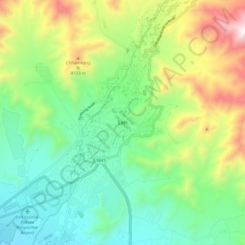
Name: Leh topographic map, elevation, terrain.
Location: Leh, Leh District, Ladakh, 0194101, India (34.00420 77.42481 34.32420 77.74481)
Average elevation: 4,294 m
Minimum elevation: 3,140 m
Maximum elevation: 5,820 m
Leh is located at an average elevation of about 3500 metres, which means that only one crop a year can be grown there, while two can be grown at Khalatse. By the time crops are being sown at Leh in late May, they are already half-grown at Khalatse. The main crop is grim (naked barley - Hordeum vulgare L. var. nudum Hook. f., which is an ancient form of domesticated barley with an easier to remove hull) - from which tsampa, the staple food in Ladakh, is made. The water for agriculture of Ladakh comes from the Indus, which runs low in March and April when barley-fields have the greatest need for irrigation.