
Mahikeng topographic map
Interactive map
Click on the map to display elevation.
Mahikeng
Close to South Africa's border with Botswana, Mafikeng is 1,400 km (870 mi) northeast of Cape Town and 260 km (160 mi) west of Johannesburg. In 2001 it had a population of 49,300. In 2007 Mafikeng was reported to have a population of 250,000, of which the CBD constituted between 69,000 and 75,000. It is built on the open veld at an elevation of 1,500 m (4,921 ft), by the banks of the Upper Molopo River. The Madibi goldfields are some 15 km (9.3 mi) south of the town.
About this map
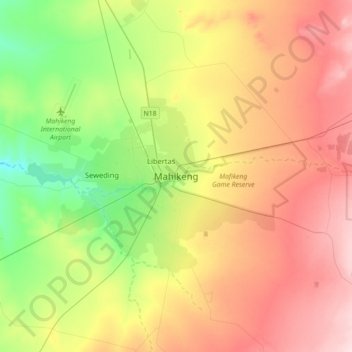
Name: Mahikeng topographic map, elevation, terrain.
Average elevation: 1,321 m
Minimum elevation: 1,208 m
Maximum elevation: 1,452 m
Other topographic maps
Click on a map to view its topography, its elevation and its terrain.
Ramotshere Moiloa Local Municipality
South Africa > North West > Ngaka Modiri Molema District Municipality
Average elevation: 1,169 m
Lotlamoreng Dam
South Africa > North West > Ngaka Modiri Molema District Municipality > Mahikeng Local Municipality > Seweding
Average elevation: 1,256 m
Tswaing Local Municipality
South Africa > North West > Ngaka Modiri Molema District Municipality
Average elevation: 1,396 m
Ramotshere Moiloa Local Municipality
South Africa > North West > Ngaka Modiri Molema District Municipality
Average elevation: 1,169 m
Ramotshere Moiloa Ward 19
South Africa > North West > Ngaka Modiri Molema District Municipality > Ramotshere Moiloa Local Municipality
Average elevation: 1,148 m
Ramotshere Moiloa Ward 17
South Africa > North West > Ngaka Modiri Molema District Municipality > Ramotshere Moiloa Local Municipality
Average elevation: 1,188 m