
Jhalawar topographic map
Interactive map
Click on the map to display elevation.
About this map
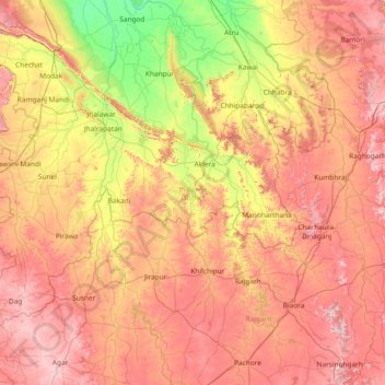
Name: Jhalawar topographic map, elevation, terrain.
Location: Jhalawar, Rajasthan, India (23.75590 75.45861 24.87055 76.94682)
Average elevation: 388 m
Minimum elevation: 238 m
Maximum elevation: 556 m
Other topographic maps
Click on a map to view its topography, its elevation and its terrain.
Phooliya Kalan Tehsil
Phooliya Kalan Tehsil, Bhilwara District, Rajasthan, India
Average elevation: 374 m
Brindawan
India > Rajasthan > Beejoliya Tehsil
Brindawan, Beejoliya Tehsil, Bhilwara, Rajasthan, India
Average elevation: 489 m
Aravalli Range
Aravalli Range, Abu Road Tehsil, Sirohi, Rajasthan, 307501, India
Average elevation: 1,339 m
Guru Shikhar, Abu
Guru Shikhar, Abu, Abu Road Tehsil, Sirohi, Rajasthan, 307501, India
Average elevation: 1,366 m