
Menlough topographic map
Interactive map
Click on the map to display elevation.
About this map
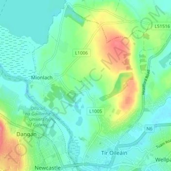
Name: Menlough topographic map, elevation, terrain.
Location: Menlough, Galway City, County Galway, Connacht, Ireland (53.28136 -9.07914 53.31974 -9.02375)
Average elevation: 19 m
Minimum elevation: -2 m
Maximum elevation: 67 m
Other topographic maps
Click on a map to view its topography, its elevation and its terrain.
South Park
Ireland > County Galway > Galway City
South Park, Claddagh, Galway City, County Galway, Connacht, Ireland
Average elevation: 4 m
Knocknagoneen
Ireland > County Galway > Galway City
Knocknagoneen, Knocknacarragh, Galway City, County Galway, Connacht, H91 R6PW, Ireland
Average elevation: 5 m
Knocknacarragh
Ireland > County Galway > Galway City
Knocknacarragh, Galway City, County Galway, Connacht, H91 K856, Ireland
Average elevation: 10 m
Menlo
Ireland > County Galway > Galway City > Menlo
Menlo, Galway City, County Galway, Connacht, H91 CF90, Ireland
Average elevation: 22 m
Ballyloughane Beach
Ireland > County Galway > Galway City
Ballyloughane Beach, Renmore, Galway City, County Galway, Connacht, Ireland
Average elevation: 7 m