
Riverhead topographic map
Interactive map
Click on the map to display elevation.
About this map
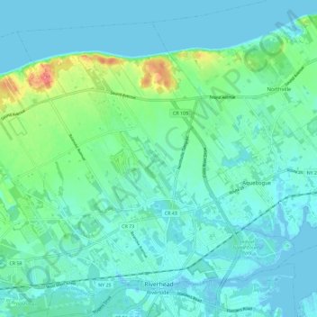
Name: Riverhead topographic map, elevation, terrain.
Average elevation: 13 m
Minimum elevation: -13 m
Maximum elevation: 69 m
Other topographic maps
Click on a map to view its topography, its elevation and its terrain.
Baiting Hollow
United States > New York > Suffolk County > Town of Riverhead
Baiting Hollow, Town of Riverhead, Suffolk County, New York, United States
Average elevation: 20 m
Luce Landing
United States > New York > Suffolk County > Town of Riverhead
Luce Landing, Town of Riverhead, Suffolk County, New York, United States
Average elevation: 11 m
Northville
United States > New York > Suffolk County > Town of Riverhead
Northville, Town of Riverhead, Suffolk County, New York, United States
Average elevation: 11 m
Jamesport
United States > New York > Suffolk County > Town of Riverhead
Jamesport, Town of Riverhead, Suffolk County, New York, United States
Average elevation: 7 m
Wading River
United States > New York > Suffolk County > Town of Riverhead
Wading River, Town of Riverhead, Suffolk County, New York, 11792, United States
Average elevation: 23 m