
Inwood topographic map
Interactive map
Click on the map to display elevation.
About this map
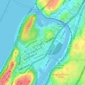
Name: Inwood topographic map, elevation, terrain.
Average elevation: 21 m
Minimum elevation: -2 m
Maximum elevation: 80 m
Other topographic maps
Click on a map to view its topography, its elevation and its terrain.
Manhattan
United States of America > New York > New York
Koreatown, Manhattan Community Board 5, Manhattan, New York County, New York, United States of America
Average elevation: 19 m
Manhattan
United States of America > New York > New York
Harlem, Manhattan Community Board 10, Manhattan, New York County, New York, United States of America
Average elevation: 16 m
Battle Hill
United States of America > New York > New York
Battle Hill, Battle Path, South Slope, Brooklyn, Kings County, New York, 11215, United States of America
Average elevation: 29 m
WQXR-AM (New York)
United States of America > New York > New York
WQXR-AM (New York), Grand Avenue, Linden Hill, Queens, New York, Queens County, New York, 11373, United States of America
Average elevation: 13 m
WNYC-AM (New York)
United States of America > New York > New York
WNYC-AM (New York), 8, Greenpoint Avenue, Greenpoint, New York, Brooklyn, Kings County, New York, 11222, United States of America
Average elevation: 4 m
Seward Park
United States of America > New York > New York
Seward Park, Lower East Side, Manhattan Community Board 3, Manhattan, New York County, New York, United States of America
Average elevation: 10 m