
Kandahar topographic map
Interactive map
Click on the map to display elevation.
About this map
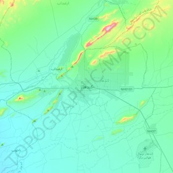
Name: Kandahar topographic map, elevation, terrain.
Location: Kandahar, Afghanistan (31.46577 65.55448 31.78577 65.87448)
Average elevation: 1,051 m
Minimum elevation: 940 m
Maximum elevation: 1,758 m
Kandahar (/ˈkɑːnðəˌhɑːr/) or Qandahar (Pashto: کندهار; Dari: قندهار; known in older literature as Candahar) is a city located in Afghanistan, with a population of about 614,118. Kandahar is located in the south of the country on the Arghandab River, at an elevation of 1,010 m (3,310 ft). It is the capital of Kandahar Province, and also the center of the larger cultural region called Loy Kandahar. In 1709, Mirwais Hotak made the region an independent kingdom and turned Kandahar into the capital of the Hotak dynasty. In 1747, Ahmad Shah Durrani, founder of the Durrani dynasty, made Kandahar the capital of the Afghan Empire.