
Cajamarca topographic map
Interactive map
Click on the map to display elevation.
Cajamarca
Cajamarca has a subtropical highland climate (Cwb, in the Köppen climate classification) which is characteristic of high elevations at tropical latitudes. This city presents a semi-dry, temperate, semi-cold climate with presence of rainfall mostly on spring and summer (from October to March) with little or no rainfall the rest of the year.
About this map
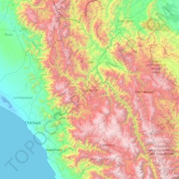
Name: Cajamarca topographic map, elevation, terrain.
Location: Cajamarca, Peru (-7.76346 -79.45845 -4.62395 -77.74130)
Average elevation: 1,456 m
Minimum elevation: -4 m
Maximum elevation: 4,585 m