
Ulhasnagar topographic map
Interactive map
Click on the map to display elevation.
About this map
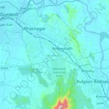
Name: Ulhasnagar topographic map, elevation, terrain.
Location: Ulhasnagar, Thane District, Maharashtra, India (19.13432 73.14600 19.25480 73.23347)
Average elevation: 47 m
Minimum elevation: 0 m
Maximum elevation: 767 m
Other topographic maps
Click on a map to view its topography, its elevation and its terrain.
Chandoli National Park
India > Maharashtra > Shirala
The park spreads along the crest of the Sahyadri Range of the northern Western Ghats. It forms and protects many perennial water channels, water holes and the Vasant Sagar Reservoir. Elevation of the park ranges from 589–1,044 m (1,932–3,425 ft). The park receives its water supply from the Warna river and…
Average elevation: 749 m