
Nubia topographic map
Interactive map
Click on the map to display elevation.
About this map
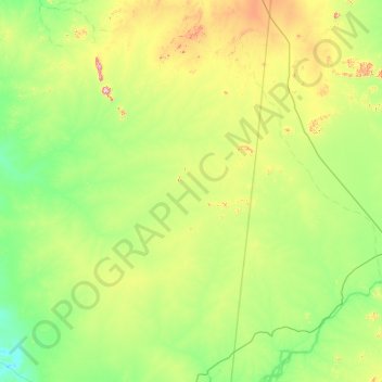
Name: Nubia topographic map, elevation, terrain.
Location: Nubia, Northern State, Sudan (19.00000 31.00000 21.00000 33.00000)
Average elevation: 379 m
Minimum elevation: 235 m
Maximum elevation: 1,114 m
Other topographic maps
Click on a map to view its topography, its elevation and its terrain.
Nile 2nd. Cataract
Nile 2nd. Cataract, Northern State, Sudan
Average elevation: 178 m
Wadi Halfa
Sudan > Northern State > Wadi Halfa
Wadi Halfa, Northern State, Sudan
Average elevation: 225 m