
Moreton Island topographic map
Interactive map
Click on the map to display elevation.
About this map
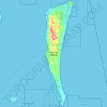
Name: Moreton Island topographic map, elevation, terrain.
Location: Moreton Island, Caboolture, Queensland, Australia (-27.36332 153.36144 -27.02127 153.46838)
Average elevation: 7 m
Minimum elevation: -1 m
Maximum elevation: 256 m
Other topographic maps
Click on a map to view its topography, its elevation and its terrain.
Caboolture
Australia > Queensland > Caboolture
Caboolture, Queensland, 4510, Australia
Average elevation: 60 m