
Make a donation
Teufelsberg topographic map
Click on the map to display elevation.
Make a donation
Teufelsberg
Teufelsberg was originally thought to be 115 metres (377 ft) high, which placed it at the same elevation as Großer Müggelberg (the summit of Müggelberge), and was the highest point in West Berlin. New measurements show that Teufelsberg is actually 120.1 metres (394 ft) high, making it higher than Großer Müggelberg.
Make a donation
About this map
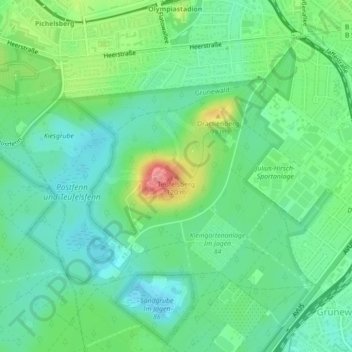
Name: Teufelsberg topographic map, elevation, terrain.
Location: Teufelsberg, Berlin, 14055, Germany (52.49767 13.24290 52.49777 13.24300)
Average elevation: 54 m
Minimum elevation: 27 m
Maximum elevation: 116 m
Make a donation
Other topographic maps
Click on a map to view its topography, its elevation and its terrain.
Make a donation
Make a donation
Make a donation
Make a donation
Make a donation
Viktoriapark
On the occasion of the elevation of the monument ideas appeared to lay out a park around it. Two years later the design of a park was put out to tender. Hermann Mächtig (*1837-1909*), since 1877 Berlin's city garden director, handed in a design, already using the name Victoria Park, in honour of Princess…
Average elevation: 45 m
Make a donation
Make a donation
Make a donation
Make a donation
Make a donation
Make a donation
Neukölln
Neukölln lies on the geological border between the shallow Berliner Urstromtal glacial valley and the Tempelhofer Berge, which are situated in the northernmost region of the Teltow ground moraine plateau, rising to the south of Hermannplatz, in what is mostly the typical low-lying marshy woodlands with a…
Average elevation: 43 m
Make a donation