
Make a donation
Thornleigh topographic map
Click on the map to display elevation.
Make a donation
Thornleigh
Thornleigh is bounded to the north by Waitara Creek and south by the Lane Cove National Park. Thornleigh borders the suburbs of Normanhurst, Hornsby, Wahroonga, Westleigh and Pennant Hills. Thornleigh offers great district views, and the topography varies greatly with many established areas built around bushland settings and into the hills to afford the great views. The northern areas of the suburb bounded by Larool Creek and Waitara Creek are leafy and lush with vegetation and native fauna including rainbow lorikeets, kookaburras, cockatoos, and bush turkeys. Majorie Headen Lookout is a vantage point which overlooks Larool and Waitara Creek Valley. The area bounded near the train station and the Comenarra Parkway include early examples of Federation and Californian Bungalow style properties.
Make a donation
About this map
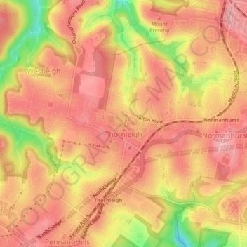
Name: Thornleigh topographic map, elevation, terrain.
Average elevation: 159 m
Minimum elevation: 72 m
Maximum elevation: 197 m
Make a donation
Other topographic maps
Click on a map to view its topography, its elevation and its terrain.
Make a donation
Make a donation
Make a donation
Make a donation
Make a donation
Nielsen Park
Australia > New South Wales > Sydney
As is common in all coastal and estuarine areas of the Sydney Region, the Park contains many rock outcrops, particularly along the foreshore headlands. These are given some added interest by the remnants of the effect of a basalt dyke that runs from Mount Trefle to Bottle and Glass Point resulting in the…
Average elevation: 14 m
Make a donation
St Leonards Park
Australia > New South Wales > Sydney > North Sydney
In 2018 it was announced that North Sydney Council would commence an upgrade of the park including improving the war memorial with a reflection pool, restoration of the Tunks Fountain and elevation on a new plinth, new benches, picnic tables, barbecues and drinking fountains, upgrades to lighting, additional…
Average elevation: 61 m
Make a donation
Make a donation
Make a donation
Make a donation
Make a donation
Make a donation
Make a donation
Make a donation
Make a donation
Make a donation
Make a donation
Make a donation
Make a donation
Make a donation
Make a donation
Make a donation
Make a donation
Make a donation
Make a donation