
Wijnendale topographic map
Interactive map
Click on the map to display elevation.
About this map
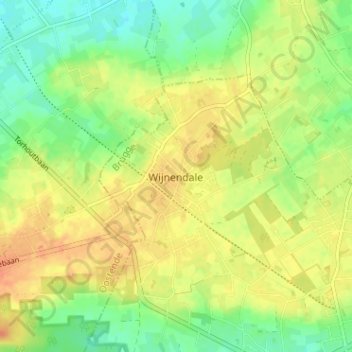
Name: Wijnendale topographic map, elevation, terrain.
Location: Wijnendale, Torhout, Brugge, West-Vlaanderen, 8211, België (51.07220 3.04875 51.11220 3.08875)
Average elevation: 32 m
Minimum elevation: 13 m
Maximum elevation: 49 m
Wijnendale ligt op het Plateau van Wijnendale, een plateau in landschap op ongeveer 40 meter hoogte, 20 meter hoger dan het lagere omliggende land.
Other topographic maps
Click on a map to view its topography, its elevation and its terrain.
Torhout
België > West-Vlaanderen > Brugge > Torhout
Torhout, Brugge, West-Vlaanderen, Vlaanderen, 8820, België
Average elevation: 22 m
De Driekoningen
België > West-Vlaanderen > Brugge > Torhout
De Driekoningen, Torhout, Brugge, West-Vlaanderen, Vlaanderen, 8820, België
Average elevation: 28 m