
Ourense topographic map
Interactive map
Click on the map to display elevation.
Ourense
The ancient city of Auria is located on both banks of the Miño river in the south-central part of Galicia, at an elevation of 128 meters above sea level.
About this map
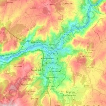
Name: Ourense topographic map, elevation, terrain.
Location: Ourense, Galicia, Spain (42.28951 -8.00350 42.39830 -7.80595)
Average elevation: 326 m
Minimum elevation: 87 m
Maximum elevation: 644 m
Other topographic maps
Click on a map to view its topography, its elevation and its terrain.