
Muzaffarnagar topographic map
Interactive map
Click on the map to display elevation.
About this map
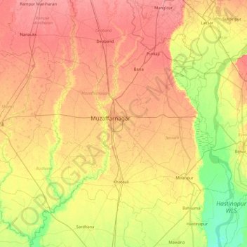
Name: Muzaffarnagar topographic map, elevation, terrain.
Location: Muzaffarnagar, Uttar Pradesh, India (29.18588 77.27910 29.71441 78.12561)
Average elevation: 241 m
Minimum elevation: 208 m
Maximum elevation: 271 m
Other topographic maps
Click on a map to view its topography, its elevation and its terrain.
Ram Nagar
India > Uttar Pradesh > Sambhal > Ram Nagar
Ram Nagar, Sambhal, Uttar Pradesh, India
Average elevation: 204 m
Ganges
India > Uttar Pradesh > Ghazipur
Ganges, Ghazipur, Uttar Pradesh, 233001, India
Average elevation: 1,626 m
Gairaha
India > Uttar Pradesh > Gairaha
Gairaha, Jhānsi, Jhansi, Uttar Pradesh, India
Average elevation: 225 m
Mountains
Mountains, Kānpur, Kanpur Dehat, Uttar Pradesh, India
Average elevation: 135 m