
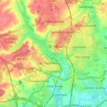
St Albans topographic map
Interactive map
Click on the map to display elevation.
About this map
Name: St Albans topographic map, elevation, terrain.
Average elevation: 100 m
Minimum elevation: 64 m
Maximum elevation: 141 m
St Albans was an ancient borough created following the dissolution of the monastery in 1539. It consisted of the ancient parish of St Albans (also known as the Abbey parish) and parts of St Michael and St Peter. The municipal corporation was reformed by the Municipal Corporations Act 1835 and the boundary was adjusted to additionally include part of the parish of St Stephen. In 1887 the borough gained city status, following the elevation of St Albans Abbey to cathedral, and the boundary was adjusted to include part of the parish of Sandridge.
Other topographic maps
Click on a map to view its topography, its elevation and its terrain.
Bricket Wood
United Kingdom > England > Hertfordshire > St Albans
Bricket Wood, St Albans, Hertfordshire, England, AL2 3QS, United Kingdom
Average elevation: 82 m
Highfield Park
United Kingdom > England > Hertfordshire > St Albans > Colney Heath
Highfield Park, Colney Heath, St Albans, Hertfordshire, England, United Kingdom
Average elevation: 87 m
Amwell
United Kingdom > England > Hertfordshire > St Albans > Wheathampstead
Amwell, Wheathampstead, St Albans, Hertfordshire, England, AL4 8EB, United Kingdom
Average elevation: 106 m
Blackmore End
United Kingdom > England > Hertfordshire > St Albans > Wheathampstead
Blackmore End, Wheathampstead, St Albans, Hertfordshire, England, AL4 8LX, United Kingdom
Average elevation: 114 m
Nomansland
United Kingdom > England > Hertfordshire > St Albans > Sandridge
Nomansland, Sandridge, St Albans, Hertfordshire, England, AL4 8EL, United Kingdom
Average elevation: 105 m
Harpenden
United Kingdom > England > Hertfordshire > St Albans
Harpenden, St Albans, Hertfordshire, England, United Kingdom
Average elevation: 119 m
Chiswell Green
United Kingdom > England > Hertfordshire > St Albans
Chiswell Green, St Albans, Hertfordshire, England, AL2 3DA, United Kingdom
Average elevation: 94 m
Napsbury Park
United Kingdom > England > Hertfordshire > St Albans > London Colney
Napsbury Park, London Colney, St Albans, Hertfordshire, England, AL2 1GF, United Kingdom
Average elevation: 78 m
Colney Heath
United Kingdom > England > Hertfordshire > St Albans
Colney Heath, St Albans, Hertfordshire, England, United Kingdom
Average elevation: 81 m
River Ver
United Kingdom > England > Hertfordshire > St Albans
River Ver, St Albans, Hertfordshire, England, United Kingdom
Average elevation: 115 m
Wheathampstead
United Kingdom > England > Hertfordshire > St Albans
Wheathampstead, St Albans, Hertfordshire, England, United Kingdom
Average elevation: 109 m
London Colney
United Kingdom > England > Hertfordshire > St Albans
London Colney, St Albans, Hertfordshire, England, United Kingdom
Average elevation: 75 m
Redbourn
United Kingdom > England > Hertfordshire > St Albans
Redbourn, St Albans, Hertfordshire, England, United Kingdom
Average elevation: 121 m
Verulamium Lake
United Kingdom > England > Hertfordshire > St Albans
Verulamium Lake, St Stephens, St Albans, Hertfordshire, East of England, England, United Kingdom
Average elevation: 102 m
Sandridge
United Kingdom > England > Hertfordshire > St Albans
Sandridge, St Albans, Hertfordshire, England, United Kingdom
Average elevation: 105 m