Geolocate

Ocean County topographic map

Interactive map

Click on the map to display elevation.

About this map

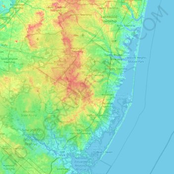
Name: Ocean County topographic map, elevation, terrain.

Location: Ocean County, New Jersey, USA (39.47520 -74.55311 40.17236 -73.96611)

Average elevation: 15 m

Minimum elevation: -2 m

Maximum elevation: 78 m

Other topographic maps

Click on a map to view its topography, its elevation and its terrain.

Atlantic County

USA > New Jersey

Atlantic County, New Jersey, USA

Average elevation: 15 m

Cape May County

USA > New Jersey

Cape May County, New Jersey, USA

Average elevation: 1 m

Granite Peak

USA > New Jersey

Granite Peak, Sussex County, New Jersey, 07472, USA

Average elevation: 332 m

Passaic County

USA > New Jersey

Passaic County, New Jersey, USA

Average elevation: 182 m