
Bukidnon topographic map
Interactive map
Click on the map to display elevation.
About this map
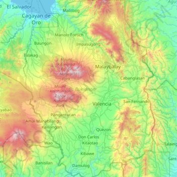
Name: Bukidnon topographic map, elevation, terrain.
Location: Bukidnon, Northern Mindanao, Philippines (7.40326 124.55244 8.60158 125.44386)
Average elevation: 686 m
Minimum elevation: -2 m
Maximum elevation: 2,859 m
Situated within Bukidnon is Mount Dulang-dulang, the 2nd highest mountain in the country, with an elevation of 2,938 metres (9,639 ft) located in the Kitanglad Mountain Range. Mount Kitanglad (2,899 m), Mount Kalatungan (2,860 m), Mount Maagnaw (2,742 m), Mount Lumuluyaw (2,612 m), and Mount Tuminungan (2,400 m), the 4th, 5th, 8th, 17th, and 30th highest mountains in the country respectively, are also found in the province.
Other topographic maps
Click on a map to view its topography, its elevation and its terrain.
Mindanao
Philippines > Bukidnon > Valencia
Mindanao, Valencia, Bukidnon, Northern Mindanao, Philippines
Average elevation: 149 m